GPS Map Camera - Timestamp
- 4.6
- Rating
- 5.00M
- Installs
- Free
- Price
 Analysis by App-foxy
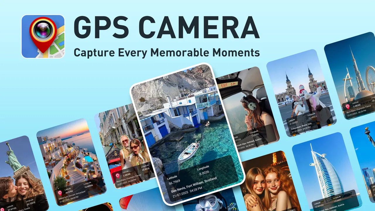
I tested GPS Map Camera - Timestamp as a practical photography app rather than treating it like a simple camera replacement. Its main idea is useful: capture a photo or video while keeping location details, date, time, and a map connected to the visual record. That makes it more relevant to field notes, travel memories, property checks, delivery documentation, and everyday proof of where something happened than to people who only want filters or portrait effects.
The app is developed by Sliver AI Photo Editor and sits in the Photography category. It is free to install, with optional in-app purchases priced from $1.99 to $19.99 per item. That distinction matters because the basic decision is easy: you can try the camera without paying first, then decide whether any paid option is worthwhile for your own workflow. I would not judge the purchase value by the presence of the camera alone; the real question is whether location and time context save you enough effort later.
In my experience, this kind of tool earns its place when a normal camera leaves too much information scattered across the phone. A regular photo may preserve technical metadata, but that is not always convenient to inspect or show to someone else. A visible timestamp and map context can make an image understandable at a glance. The strongest reason to use it is not decoration; it is organized visual evidence.
You May Also Like

 Blood Strike: 2.5 Anniversary
Blood Strike’s Loadouts Turn Every Drop Into a Tactical Gamble
A close look at Blood Strike’s custom loadouts: how fast access to signature weapons reshapes its battle royale rhythm, rewards preparation, and narrows the gap between fights.

 Pandora - Music & Podcasts
Pandora’s Music Is Easy to Start, but Harder to Recover
Pandora’s strength is its low-effort path from a seed to a station. Its weak spot is how much confidence it asks you to place in connection, setup, and quiet recovery.

 8 Ball Pool
 Is Built on Rivalries, Rematches, and Routine
A close look at the rivalries, rematches, shared routines, and unanswered safety questions that turn a quick pool match into a persistent mobile community.

 Samsung Music
’s Quiet Strength Is Playing What You Already Own
Its reach comes less from spectacle than from dependable access to a personal library. That simplicity is both the app’s strongest retention engine and its ceiling.

 AccuWeather: Weather Radar
AccuWeather Review: A Quick, Clear Forecast for Everyday Decisions
For everyday plans, the best forecast is the one you can understand quickly. AccuWeather makes rain timing, radar, and local conditions easy to act on, with a few trade-offs.

 Hill Climb Racing
Why Hill Climb Racing Still Turns Crashes Into One More Run
A tiny car, a bumpy hill and one more upgrade: Hill Climb Racing keeps resurfacing because its simple chaos makes every near-miss feel personal.
More From Our News Desk



How the camera fits into real photo workflows
I find this camera most useful when I plan the capture and the later handoff together: first decide what the image needs to prove or explain, then frame it so the subject remains clear alongside its location and time context. That simple discipline keeps a stamp from becoming visual clutter and makes a set easier to review. It also leads to a practical question: what should I check before sharing or relying on those images?
A straightforward way to attach context to images
GPS Map Camera - Timestamp is built around combining the image with details that are usually handled separately. The store summary highlights GPS-based location geotagging, date, time stamp, maps, photos, and videos. In practical terms, I see it as a camera for situations where the surrounding facts are almost as important as the subject itself.
Imagine checking a rental property before handing it back. You photograph a wall, a meter, or a damaged fixture, and the visible time and place help you sort the record later. The same approach can help during a hiking trip, when several similar landscape photos would otherwise be difficult to place in order, or while visiting multiple work sites in one day. Instead of opening a separate map application and trying to reconstruct the route afterward, the image can carry more of its own context.
That workflow is especially helpful for people who share photos with someone who was not present. A family member looking through travel images can understand where a picture was taken without asking for a separate explanation. A colleague reviewing site images can identify the relevant location more quickly. The benefit is modest for one isolated photo, but it becomes more noticeable when a collection contains many images from different places.
Why the map element can be more useful than a plain timestamp
A date and time are helpful, but they are not always enough. If I take several pictures during a long day, the clock can tell me their sequence while saying little about the route. A map adds a second layer of orientation. It can help me distinguish images taken at nearby stops and gives the viewer a visual cue about the setting.
There is also a practical sorting advantage. When I return from a trip or finish a day of inspections, I can group images by the places represented in them instead of relying only on memory. That does not replace a proper records system, but it reduces the mental work involved in reviewing a camera roll. For a user who regularly documents locations, that is a more meaningful improvement than another set of visual effects.
I would still treat the map as supporting context rather than absolute proof. A camera app can display a location, but the usefulness of that information depends on the phone’s positioning and the circumstances of the capture. For casual documentation, that is usually acceptable. For disputes, regulated records, or work that requires a formal chain of custody, I would use a dedicated professional process as well rather than relying on a consumer photography app alone.
Photos and videos serve different purposes
The store summary specifically includes both photos and videos. That broadens the possible use cases. A still image works well for a visible condition, a completed task, or a memorable place. Video is more useful when movement or sequence matters, such as recording a machine operating, showing a route, or documenting a walkthrough.
The trade-off is that video records can become harder to review than still images. A stamped frame may communicate the basic context quickly, while a video may require someone to watch the entire clip. I would use video when the action itself matters and still photos when the priority is quick comparison. The app is more flexible because it covers both, but flexibility does not mean every format is equally efficient for every job.
What I would check before relying on it outdoors
Location-based photography works best when I pause briefly before capturing an important image. I would make sure the phone has a usable position, avoid taking the photo immediately after moving between locations, and review the result before leaving the scene. That small habit is more valuable than blindly trusting any automatic label.
For a travel album, a quick glance is enough. For a work record, I would also keep the subject clearly visible and avoid covering important details with the timestamp or map presentation. The overlay should support the photo, not compete with it. If the location marker or time information takes up too much of the frame for a particular subject, a conventional camera image alongside the contextual capture may be the better workflow.
Compatibility and the first installation decision
The app requires Android 7.0 or later, so it is aimed at a wide range of Android phones rather than only recent hardware. The current version is 1.1.0. That makes the first step simple for compatible users: install it, try the free access, and see whether the location-and-time presentation fits the way you already take pictures.
The age rating is Everyone, which suits a general-purpose camera utility. I would still introduce it carefully to younger users if the photos reveal home, school, or travel locations. The rating describes general suitability, while responsible sharing of geotagged images remains a separate concern.
How it compares with the usual alternatives
The standard phone camera is usually faster for spontaneous shots and often offers a more familiar shooting experience. If I am taking a portrait, a food photo, or a quick family picture, I would not automatically choose a GPS-focused camera. The ordinary camera is the better default when location context is irrelevant and speed matters most.
Map applications are useful for planning and navigation, but they are not designed to turn every captured image into a location-aware visual record. A photo gallery can sort images by time and sometimes by place, yet that information may be hidden in menus rather than visible in the image itself. GPS Map Camera - Timestamp occupies the space between those tools: it makes the context part of the capture workflow.
Dedicated field-reporting or inspection software can be a better choice for teams that need forms, approvals, structured reports, or controlled records. This app looks more approachable for individuals and small, informal workflows. I would choose it for convenience, not as a substitute for specialized compliance software.
Where the free model makes sense
Because the app is free to install, there is little reason to pay before testing whether it solves a real problem. I would begin with a few representative situations: one indoor image, one outdoor image, a sequence from a short trip, and a brief video if that is part of my intended use. The test should focus on whether the resulting context is readable and useful, not simply whether the camera opens.
Optional purchases range from $1.99 to $19.99 per item. Those prices create a wide difference between a small convenience purchase and a more substantial commitment. Since the exact value of each item depends on what is offered inside the app, I would inspect the purchase screen carefully and avoid assuming that paying automatically improves the core experience. The sensible approach is to connect any purchase to a specific benefit I will use repeatedly.
For someone who only wants occasional location-marked memories, free access may be enough. For a person who documents sites every week, a paid option could be reasonable if it removes a recurring annoyance or provides a capability that genuinely changes the workflow. I would measure that value in saved sorting and reporting time, not in the number of available camera controls.
Small workflow improvements that make a difference
One useful habit is to capture a broad establishing image before taking close-ups. The broad image shows the surrounding context, while the close-up records the detail. When reviewing the set later, the map and timestamp become much more useful because I can connect the detail to a recognizable place rather than seeing a series of isolated surfaces.
A second tip is to keep a consistent order during repeated visits. I might photograph the entrance first, then the main subject, then the surrounding area, and finish with a short video when movement matters. The app does not need to provide a complex project system for this to help; the consistency comes from the photographer. The location-aware capture then reinforces a predictable record.
A third trade-off concerns sharing. A stamped image is convenient for communication, but it can also reveal more than I intend, including where a private place is located and when the image was taken. Before posting publicly, I would consider whether the visible map and time are necessary. For private records, they may be valuable. For social sharing, a normal camera image may be safer and cleaner.
Who will get the most value from it
I think the best audience is people who repeatedly need to connect a picture with a place. Travelers can use it to make large photo collections easier to understand. Outdoor enthusiasts can keep a visual trail of stops. Property owners, contractors, and independent workers may appreciate a quick way to attach context to site images without building a report from scratch.
It can also suit anyone who often sends photos as explanations. If I am showing a friend where a trail begins, documenting the condition of a borrowed item, or recording the progress of a small renovation, a visible time and location can reduce follow-up questions. The app is most valuable when the recipient needs context and I want to provide it inside the image rather than in a separate message.
I would recommend skipping it if I mainly want advanced creative photography, polished portrait controls, extensive editing, or the fastest possible snapshot experience. Its appeal is practical documentation. Someone who never needs geotags, maps, or timestamps will probably find a normal camera less distracting.
Questions I would answer before installing
Is it really free? Yes, the app is free to install, while optional in-app purchases are available. I would start without spending anything and decide only after seeing whether the contextual camera workflow is useful in daily life.
Can it be used for both pictures and video? The app’s store summary covers both photos and videos, so it is intended for more than still-image capture. I would choose the format according to the evidence I need: stills for quick comparison and video when motion or a sequence is important.
Will it replace my normal camera? Not for everyone. I would keep the regular camera for casual images where a map or visible time would be unnecessary. This app is better treated as a specialized camera mode for location-aware records.
Is it suitable for professional documentation? It can be useful for informal site records and personal documentation, but I would not assume that a consumer camera app meets every organization’s requirements. If a job demands formal verification, approvals, or a controlled archive, dedicated software is the safer choice.
Does the Everyone rating mean I can share every image freely? No. The app is rated Everyone, but geotagged images can expose sensitive places and schedules. I would review the visible context before sending or publishing anything, especially when the photo includes a home, school, or private workplace.
My buy-or-skip verdict
GPS Map Camera - Timestamp is a focused photography utility with a clear practical purpose. I like it most when the image needs to explain where and when something happened, not merely what it looked like. The combination of GPS context, map presentation, date, time, photos, and videos gives it a useful role between a standard camera and a formal reporting tool.
The free entry point makes the decision low-risk. I would install it, test the capture and review workflow in the exact situations I care about, and only then consider an optional purchase between $1.99 and $19.99 per item. That is the honest way to judge its value, because a feature that sounds useful in theory may not improve a casual photographer’s routine.
My recommendation is positive for travelers, field workers, property users, and anyone who regularly needs location-aware visual records. I would skip it for creative photographers seeking editing depth or for users who simply want an uncomplicated everyday camera. If your photos regularly need an explanation of place and time, this app is worth trying; if they do not, the extra context may only get in your way.
With an average rating of 4.6 from around 1.4 thousand ratings and more than 5 million installs, it has clearly attracted a substantial Android audience. Those figures are encouraging, but my final judgment still comes from fit: the app earns its space on my phone when it prevents the small but repeated hassle of reconstructing where a photo was taken and why it matters.
FAQs for GPS Map Camera - Timestamp
01What is GPS Map Camera - Timestamp, and how does it work?
GPS Map Camera - Timestamp is an app that allows users to take photos with embedded location data and timestamps. It uses your device’s GPS to capture the exact location, date, and time when the photo is taken, making it ideal for travel enthusiasts, field workers, and anyone needing detailed photo documentation.
02Can I customize the information displayed on the photos?
Yes, GPS Map Camera - Timestamp offers customization options for the information overlay. Users can choose what details to include, such as latitude, longitude, altitude, date, and time. Additionally, you can adjust the text size, color, and position on the photo to suit your preferences.
03Is an internet connection required to use this app?
An internet connection is not necessary to use GPS Map Camera - Timestamp for capturing photos. However, a connection may be required for initial map downloads and updates. The app uses offline GPS data to tag locations, ensuring it works even in remote areas without internet access.
04How accurate is the GPS tagging feature in the app?
The GPS tagging accuracy depends on the device’s GPS hardware and environmental conditions. Generally, the app provides precise location data, but accuracy may decrease in areas with poor satellite visibility, such as dense urban areas or indoors. However, the app performs well under most outdoor conditions.
05Is my location data stored or shared by the app?
GPS Map Camera - Timestamp prioritizes user privacy. The location data is stored locally on your device within the photo metadata and is not shared with external servers or third parties. Users have full control over their data and can choose to share photos with location tags as needed.
Pros
- Easy to use with intuitive interface.
- Customizable timestamp settings.
- Seamless integration with map services.
- Accurate location tagging feature.
- Supports multiple photo formats.
Cons
- Requires constant internet connection.
- Limited free version features.
- Ads can be intrusive at times.
- High battery consumption during use.
- Occasional GPS signal delays.

GPS Map Camera - Timestamp
Gallery